|
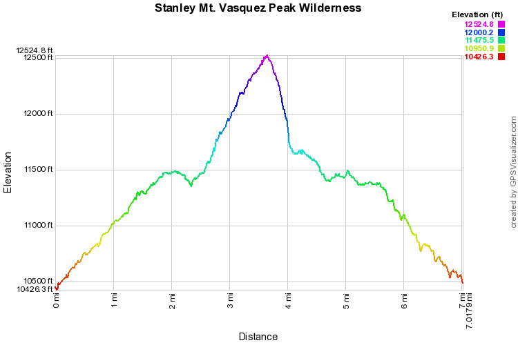
Directions: Stanley Mountain is on the edge of the Vazquez Peak Wilderness and can be reached two ways. The typical route starts at the top of Berthoud Pass. This route however, starts from the same parking area as described in the Butler Gulch (winter) hike. From Denver, take I-70 W to 40 North. Before switchbacking up to Berthoud pass, make a left towards the Big Bend Campground. Take Henderson Mine Road until the see the sign for Henderson Mine and the dirt road leading to a parking area on the right. To the right of the parking area you will see a trail and a Continental Divide National Scenic Trail marker. This is a spur trail that leads to the CDT. The Spur trail switchbacks along the slope of the ridge with intermittent views of Red Mountain, the Henderson Mine, and Butler Gulch. When you reach the trail junction make a right following the sign to Stanley Mountain. Beware, the mileage on the sign is very off, it is not a mile to Stanley Mountain, it's more like 2.5 mi.
The trail skirts the side of the mountain and provides wonderful views and remarkable wildflowers in the Summer. The prettiest spot is just south of Vazquez Pass, remember this spot as you will wind up here again, there is a faint trail heading north, but stay on the main trail. You soon break tree line and ascend the ridge. The trail here is very steep but the views are magnificent in all directions. Eventually, you will see a mound of boulders that marks the summit of Stanley Mountain. Enjoy the views of Vazquez Peak and the Vazquez Peak Wilderness stretching north towards Winter Park. Here you have two options, you can go back the way you came, or you can look for a large cairn to the west. If you follow the cairns here you will descend, off trail, towards Vazquez Pass. If you choose this option do so at your own peril. The cairns are easy to lose. Stay to the south (left) of the cairns and keep looking for the trail, the trail will put you down just south of the actual pass. If you stay to the right, as I did on this trail, the slope gets very steep with loose rock. After you've enjoyed your time at the pass, head south on faint trail until you meet up again with the CDT. From here you retrace your steps back to the parking lot. The cool thing (among others) of this trail is that the next time you drive up Berthoud Pass, you'll be thinking about how you actually hiked up this mountain when you summited Stanley. |
- HOME
- ABOUT
-
HIKES BY REGION
-
NATIONAL PARK HIKES
- BENT'S OLD FORT NATIONAL HISTORIC SITE
- BLACK CANYON OF THE GUNNISON NATIONAL PARK
- COLORADO NATIONAL MONUMENT
- CURECANTI NATIONAL RECREATION AREA
- DINOSAUR NATIONAL MONUMENT
- FLORISSANT FOSSIL BEDS NATIONAL MONUMENT
- MESA VERDE NATIONAL PARK
- ROCKY MOUNTAIN NATIONAL PARK
- GREAT SAND DUNES NATIONAL PARK
- HOVENWEEP NATIONAL MONUMENT
- SAND CREEK MASSACRE NATIONAL HISTORIC SITE
- YUCCA HOUSE NATIONAL MONUMENT
- HIKES BY CATEGORY
- NEWS
- WEBCAMS
- $UPPORT GHC
- INTERACTIVE MAP
Stanley Mountain 12,512ft
Continental Divide National Scenic Trail
Vasquez Peak Wilderness
Arapaho National Forest
Date Hiked: August 16, 2013
Distance: 7 mi (RT)
Elevation Gain: 2,100ft
Elevation Min/Max: 10,426 to 12,521ft
Trailhead Lat/Long: 39.770973N; 105.853670 W
Managing Agency: U.S. Forest Service
Fee: None


