|
DIRECTIONS: This hike begins at the Peaceful Valley winter trailhead. The trailhead is located on County Road 92 just off of the Peak to Peak Highway (State Highway 72). The road to Peaceful Valley starts at a bend in the highway just south of where Hwy 7 intersects 72 south of Allenspark.
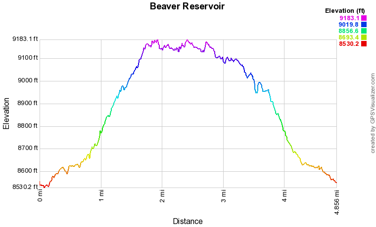
Beaver Reservoir is a popular spot for winter recreation and serves as a trailhead for snowshoe and ski trips into the Indian Peaks Wilderness. While you can drive to the reservoir year-round, there is a nice hiking loop that makes the reservoir a destination, rather than a starting place. The reservoir sits on an alpine flat, just south of the Peaceful Valley and Camp Dick Campgrounds. These campgrounds are closed in the winter and the road is gated at Peaceful Valley. This trail system is popular and typically boot packed so you may or may not need your snowshoes or skis. The loop travels these trails and climbs up to Beaver Reservoir, follows the dirt road, and descends back down to Peaceful Valley. Along the way you'll travel through pristine pine forest and get treated to some nice views of the Indian Peaks.
From the winter gate closure before the Camp Dick Campground, follow the trail to the left of the Middle Saint Vrain Trail sign. This trail is actually the Buchanan Pass Trail. The trail passes through beautiful thick pine forest, marked with blue trail blazes. Before long there is an un-signed fork in the trail, go either way, these trails merge in a few hundred feet. Before long you'll reach the junction for the Sourdough Trail. Turn left and head up hill on the Sourdough Trail. The trail climbs through the forest along switchbacks for about half a mile before reaching a trail junction, this is the start of the loop for this hike. I suggest taking the right fork to begin. The trail continues to climb with some views of the Indian Peaks through the trees if you are lucky. After another 3/4 mile of hiking you'll reach the Coney Creek Road. Turn left (north) and follow the road for about 50 feet to the Beaver Reservoir Trailhead. You have now reached Beaver Reservoir. At the trailhead, head left and follow the dirt road to the east along the shore of the reservoir. The next 3/4 of a mile follows the dirt road with wonderful views across Beaver Reservoir. In the distance you are treated to views of Mt. Audubon to the south, the iconic Sawtooth Mountain rising sharply, the jagged ridge south of Ogalalla Peak is also visible with Copeland Mountain's rounded summit on the northern end of the viewshed. A marvelous view year-round. Follow the round past the eastern terminus of the reservoir and look for the trailhead on the northern side of the dirt road. It is 3/4 of a mile from the Beaver Reservoir Trailhead. Turn left (north) and re-enter the woods. The trail descends the wooded slopes, crosses some footbridges, has nice mountain views, and closes the loop after 1.2 miles. From the close of the loop continue downhill on the Sourdough Trail and turn left at the Buchanan Pass Trail junction to return to the winter trailhead. This a wonderful but popular trail system. The majority of the trail hikes along a north facing slope so it tends to hold the snow late in the season. However, with so many people using these trails, they are typically packed down well. Whether you wind up hiking or snowshoeing, it is still a wonderful place to spend a winters day. |
- HOME
- ABOUT
-
HIKES BY REGION
-
NATIONAL PARK HIKES
- BENT'S OLD FORT NATIONAL HISTORIC SITE
- BLACK CANYON OF THE GUNNISON NATIONAL PARK
- COLORADO NATIONAL MONUMENT
- CURECANTI NATIONAL RECREATION AREA
- DINOSAUR NATIONAL MONUMENT
- FLORISSANT FOSSIL BEDS NATIONAL MONUMENT
- MESA VERDE NATIONAL PARK
- ROCKY MOUNTAIN NATIONAL PARK
- GREAT SAND DUNES NATIONAL PARK
- HOVENWEEP NATIONAL MONUMENT
- SAND CREEK MASSACRE NATIONAL HISTORIC SITE
- YUCCA HOUSE NATIONAL MONUMENT
- HIKES BY CATEGORY
- NEWS
- WEBCAMS
- $UPPORT GHC
- INTERACTIVE MAP
Beaver Reservoir (via Peaceful Valley)
Roosevelt National Forest
Date Hiked: January 31, 2021
Distance: 4.8 mi (RT)
Elevation Gain: 850 ft
Elevation Min/Max: 8,530 to 9,176 ft
Trailhead Lat/Long: 40.13108, -105.50388
Managing Agency: U.S. Forest Service
Fee: None


